Monday, March 30, 2020

Just a nice morning.

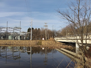
A little more dry with less snow coverage ending March 2020.   A relatively great last couple weeks to really look at the ground forms without snow cover or any vegetation growth.  The Trimble building really pushed it to the maximum edge, much like the Trimble residence in Wakanda Shores did (and got a DNR citation for it) to maximize the nearness to the shore.   Of course, this slope was in that shape decades back and it does bring it back out from the vegetation that had grown up on it in the preceeding 50 years, it really stands out here where we can see the new rip-rap in preparation for the lake level raises.  

That's pretty cool.   

But what is the that maximum slope angle that will last long term?   The rumor was there was a lot of debris used for fill, such as old cars at in this area.  
Main street was pushed out over it a couple times and led to an expensive reconstruction.  For a wider street which further distances downtown away from the lake through the barrier of the speeding automobiles on the river of cars.

The concept of the lake trail or path that would extend from LaPointe park, or the old city pumphouse location, and wrap all the way to Point Comfort will likely not get around this section without considerable expense now.  The best feature would be a wharf or pier out in the water but the sheer expense for the benefit of the public is very unlikely.


With a large section of the old trail system from a hundred or so years ago reworked in some fashion, there are really only slivers of anything before 1957 that might still be worn into the hillside for that real authentic connection to that particular past.

And even that "rustic" past, when it was current, was actually built with a "rustic" style at the time they were new in many cases.


Like most springs into summer, below the water is very clear at Wolske Bay.  Above, Wilson Creek has more current this time of year that has a more clouded silted stream.


This dock configuration is nice, but it would be nice to see more improvements for shore fishing on the outer bay, or lake side, of the Wolske Bay park.


Sunday, March 22, 2020

How to start an urban myth

A fun series of investigations into local Menomonie myths would be great, any and all of them.  It's already something the Mayor of Menomonie has done with Wolske Bay, you know, the originating location of all the algae in the world according to his "garage-logic" lake "fixing" schemes.

But we know better.   We know Wolske Bay is just a really cool creation that came to be back when big 1950's civic/ business leaders of Menomonie pushed for a bigger, deeper lake that resulted in the overdue replacement of the wood dam backing up the Red Cedar River at an increased head level.  (And the "algae" that  appeared here on Lake Menomin before was still there after.)

The neighboring park, Lakeside Park, site of the former waste water lagoon for Lange Canning Co. was built before the lake level was raised, and it did contain high-nutrient waste.  The area was low and some preparation barrier for increased river height was made.  

In fact, the smaller area closer to the roadway has always been absolutely boggling.  Well, actually, here's some  pictures from March 21, 2020.   Where the water from springs to the north is crystal clear, the lake water crystal clear, there is this:


Now, the condition of the water in this area is always cloudy but the aquatic vegetation that separates it from the bay at the southern tip of Lakeside park seems to always filter out whatever is causing the clarity of the water in this somewhat separated pond.   The T.M.L.I.A. does not seem interested in this pond nor does the Mayor of Menomonie.   I suppose, it doesn't really have a name, it can't get a scapegoated public image from the political podium of city hall.  No one is down there making up solutions or getting neighborhood petitions for the city to do anything about this little bay.  No "look at me" option for the big civic and business leaders downtown to get the press for.


Maybe now there will be a something to it.   The urban myth of lead paint under Menomonie's lakeside park may start now:


You can see how good the "telephone" game really is at relaying information on the internet and that your real memory is maybe not as good as you think it is.  To credit, there may be Lakeside Aluminum or Globe Iron Works waste, for instance, that had something going on that did get buried, but they located more were to the south,  to give some credit to the "paint plant" pollution angle.  Even without confirming the information about the wastewater in the settling lagoon, the lead paint image over the park "for the kids" is a rumor that can spread into other interesting stories from this point on.

And it will lead to further Lake Menomin pollution myths, such as the goose poop being the cause of it all. 
(No, seriously, talk to people when you're out and about starting in June and you will find someone who will blame ALL the green colorization of the lake on goose poop near the shores of the lake.)

No one talks about the massive hog pen near here that was around before any of this, though, do they?


We saw that with the "Kentucky Fried Chicken Siren" internet joke post that led to genuine rumors of a Kentucky Fried Chicken franchise coming to Menomonie.
(Since edited to highlight this was a joke.)


The particular funny part is the same joker is also complaining about the lake causing a lack of tourism.   But maybe the complaining about the lack of tourism because of the lake is also a joke? 
"Peter Gruetzmacher, owner of the Silver Dollar and Jake’s Supper Club, said there are plenty of reason tourists should want to visit Menomonie, but tourists are turned off later in the summer when the lake turns green."
 Now, we know the "turned off" later in the summer reason but it is too bad the "plenty of reason tourists" should want to visit Menomonie were never listed.   


Sunday, March 8, 2020

Ending winter, a nice day, a short walk

Just a little past the prime time to catch the land forms that you won't notice once the foliage springs to its seasonal form.   Should be the week to see the Lions Klunker go down, maybe even tomorrow.   Has this even ever been capture on film or video?

Do the car drivers on the bridge even notice it, or even look at the lake?


The water is open a little more from last week, with less snow and more gradual warming it will be interesting to see if there is a "main stream" or current in the reservoir.  Below, the point of land on the opposite bank is the LaPointe Park.  Since the second bridge (rail in view) was added the value of that park has slowly been lost. (somewhat stolen.)


The rail on the bridges are tall.   A fun way to interact with Menomonie is walking around downtown and on the trails, except due to the traffic volume (amount and sound).   A circle tour on the bridges taking in the dam side and lake side in one swoop is usually not as delightful as the edited commercial tourist shows broadcast.   It's a completely missed opportunity by the City of Menomonie, but then regular people are not usually given the opportunity to make a thing happen.   (And judging by the amount of litter and lack of consideration by some, why should the City do anything?)


Once the vegetation springs to life below this will be a fun view to snap a photo of. 

The largest "Wolske Bay" sign is the larger street sign

Menomonie Lakeside park is the repurposed Lange Canning Co. high-nutrient Waste Lagoon.


One of the most natural park settings at the confluence of Wilson Creek and the Red Cedar River is disrupted by the terminal ends of the Federal and State highways bridges that allow excessive speeds of motorists.  Walking across the south end of the bridges is more dangerous, especially with younger and less able people.  To cross from the upper part of La Pointe park to the Wilson Place Museum is only for the adventurous.   Sure, people could walk uphill a block and over the North Campus overpass, and back down, to cross another busy vehicle intersection.  Maybe this is why Wilson Place Mansion didn't get as many visitors since the mid-'90's?


The difference between the UW-Stout standard and the City of Menomonie standard is evident in this stretch of sidewalk.   Twisted concrete tripping hazards and ankle-snapping opportunities abound.   This isn't just a post-winter condition, either.  The chances of vehicles striking people are rather high at this intersection as red-light running is rather common.  If it were a Menomonie baseball field it would look like this at all.  


 Up above is a sampling on a light traffic Sunday morning.  Wolske Bay road sees a large amount of motorists speeding, robbing the enjoyment of a neighborhood walk routinely.  In the sample above is the curious case of Menomonie standards and sidewalks, even when the concrete was being replaced ( a couple years ago) and the traffic count here validates the city's own rules to have a sidewalk on the other side, none was placed there.  
The missed opportunity for trail bump-outs for the Junction to Stokke Trail connection on the old rail line were sadly not taken.    A three post red-reflector "gate" forces users of the Junction Trail onto questionable 1980's-era sidewalk.


Menomonie Public Library

Menomonie Purple Martin birdhouse

The "Milwaukee" rail line passed under here to the left lower corner on its way to Cedar Falls until 1902.

Saturday, January 18, 2020

First views of Menomin and the Waterpark

Dropping into Menomonie a couple decades back, this author was rather excited to be in a new town that had a lake, among other exciting sounding offerings at the University of Wisconsin Stout.   With some other smaller town lake experiences, and coming from a personal/professional big lake experience, the sailing club sounded like something I wanted to do.

Only thing is that when I got it here, the listed club wasn't anywhere to be found on campus.

No big deal, there was a lot to take in.  It was overwhelming in some respects.   While the roommate assigned to me really sucked, the room had a great view.  (It only took me about 16 years to finally get in to see the Wilson Place Mansion after literally overlooking it for some years.)  The view of the lake was nice, eventually the last room on campus was at the end and it was really quite excellent. 

Below is the view that I came to know on the many walks between residence and class and work.

It is quite interesting that my future home currently is in view although it's not seen.  


In the relatively short time I have been here I have seen a lot of Menomonie, not the UW Stout part, but the real Menomonie disappear.   Little by little.   For instance, this stairway below went up to the parking lot that is behind Hovlid hall.  It is gone now, but for years this kind of what was my backyard.   Now it is the new Stout North Campus cafeteria that took over the parking lot area above.   This scene gone.


Now if someone in 50 years looks at it, would it read something like, "rustic staircase," and someone like me will wonder where it was? 

Of course at the time, a couple decades ago, I had no idea what was there before me.  As I come across more and more information about Menomonie I am floored by the amount of homes that have disappeared to make room for UW Stout expansion and parking lots.  Not to mention the closing of roads and elimination or outright theft by the city and state of property for "renewal" efforts or road widening.

And then in the modern news it appears there is a "housing shortage" in Menomonie.  


My first walk off-campus was north along the Omaha rail that eventually led me to Kmart.   Kind of a random first adventure on my first night in Menomonie.   I don't have any pictures of the railroad tracks I was following and I didn't know much about anything I was passing at that time.   Now it is the rail-to-trail Junction Trail.  

Way off my radar at the time was the Wakanda Water Park.   I really enjoyed walking, running, and biking, down to Wakanda park in those days.  The lightly wooded and large parks of Menomonie have been one of my favorite aspects of this city.  

I thought this article was really interesting.  The note that the water park was something on the list of things Menomonie desired since 1960 really hit home on the current me.  If I had read this article 20 years ago that part wouldn't stand out to me.


Why now?   I think it is because with the on-going research and discussion, that year, or more specifically it was 1958 when Menomonie saw the realization of the "big new lake," and in 1959 when that extra depth didn't improve to the desired "lake" people thought it might be was evident.  


With so many people that were here in the 1950's and 1960's that will tell about the algae that existed then, I have to wonder where the people who claim there was never an algae presence "before" came from?  

When pressed for more information on this, the "it was clear before" demographic will sometimes later add something like, "it wasn't AS bad," or it "was never THIS bad," or "it is getting worse."

There can't be two contradicting accounts.

I could showcase clear water every year for the last couple decades but at the same time produce a green photo of the lake in each same year.   Why?  That's the algae cycle, it is a photosynthetic creature and they are feeding and multiplying like crazy until they kill each other off, and then release their blue color, their decaying odor, and possibly toxins (if present.)  

The environment needs balancing.

Next up, we're hitting on the crumbling lake shore, a bigger problem that Menomonie should be addressing.

Thursday, January 9, 2020

How to destroy a public park


The beginning of the end of the pond bank park, the "rustic bridge," the trails.   

Leader-Telegram Apr 09, 1948
Mayor Randy Knaack


Ever wonder what happened to the Wilson Creek drive?   Maybe it wasn't really pollution?

How did Wilson Park survive?

Sunday, January 5, 2020

Then, now, and then what?

Creating a lake. 

The old "mill pond" just wasn't a well-enough feature for the company town that the company was leaving.

While the Knapp, Stout, and Co. was present we know that Wilson Creek and Riverside park were popular locations, as well as "point comfort" before there was a road access down there.  Likely, Evergreen cemetery was used as a park, too, this would be in that period where cemeteries had different meaning before the modern death industry and the more modern "public park" and recreation spaces were in existence.    Who would have thought a multi-million dollar water park would be in existence back in 1902 in Menomonie?


A lesser mentioned park, the "pond bank park" appears alongside Riverside park for funding early in Menomonie history.   We have to wonder if the names were simply called what they are because of what they are, "riverside" and "pond bank?"   

But no such "mill pond" for Menomonie, as Senator Stout declared the slightly raised level "a lake."


But what is a lake?   Like most words, each individuals experiences and expectations come with a varied defintion.

Some definitions but this one seems fitting:

Definition of lake
: a considerable inland body of standing water also : a pool of other liquid (such as lava, oil, or pitch)

Size, shape, depth, use, and a host of other criteria a not present in the definition.

So, we have a lake.


Since 1958 Menomonie has had a big, upgraded lake.  So, where are those who pushed for the raising in Menomonie at on their opinion of their modern creation?

What would the citizens of Menomonie from the first half of the 20th century think of the new direction from their humble "mill pond" upgrade?


Where next?

More roads?  More encroachment?   More dredging?